
Product Images


In stock
Smart shoppers OnBuy it!
Interest-free payment options available
See full product description & details
Delivery: Standard (£7.99) | Mon 13th - Wed 15th Jul
Sold by: Ecommerce Enterprise
Returns: 30 days
180-day payment protection


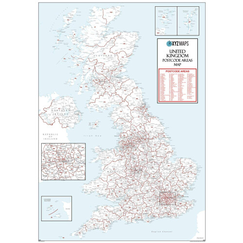
Summary
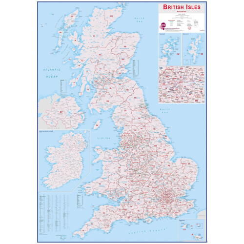
Walsall
-
WS-
Postcode
Wall
Map
-
Paper
The
Walsall
Postcode
Sector
Wall
Map
Shows
Detailed
Postcode
Sector
Boundaries
with
its
Associated
Postcode
Sector
Label
(WS8
2,
WS8
3)
on
a
Comprehensive
Background
and
is
Perfect
for
Determining
Postcode
Boundaries
for
Sales,
Logistics,
Planning
Mailshots
or
as
a
Regional
Reference
Guide.
This
Wall
Map
Covers
the
Whole
of
the
WS
Postcode
Area.
Map
Details:
Title:
Walsall
-
WS-
Postcode
Wall
Map
Scale:
1:34,926
Sizes:
A0
(119cm
x
84cm)
or
For
Extra
Clarity,
Double
Size,
2A
(119cm
x
168cm).
Edition:
First
Edition
SKU:
G123
Map
Features:
Postcode
Sector
Boundaries
in
Red
with
Associated
Postcode
Sector
Labels
(WS8
2)
Ordnance
Survey
1:50
000
LandRanger
Map
Background
in
Colour
including
Motorways,
Primary
Roads,
Major
Towns,
Cities
and
Villages.
Map
Benefits:
Xtreme
Accuracy
Postcode
Boundaries
with
Clear
Regional
Mapping
for
you
to
Plan
Sales
and
Marketing
Campaigns,
Leaflet
Drops,
Postal
Mailings,
etc.
Use
to
Allocate
Postcode
Districts
and
Sectors
to
Sales
Territories.
Use
Marker
Pens
on
the
Plastic
Coated
version
and
then
Wipe
Off.
Use
Marker
Pins,
for
Client
Locations.
Brand:
XYZ
Maps
Model:
G123-Paper
Color:
Multicolour
Size:
A0
-
1189mm
x
841mm
Manufacturer:
XYZ
Maps
Ltd
Release
Date:
6
December
2022
Details
| OPC | PDV6VGW |
|---|---|
| Brand | XYZ Maps |
| Codes | 5060688684980 (EAN) |
| Seller | Ratings | Warranty | Returns | Price | Delivery | Total | Quantity |
|---|---|---|---|---|---|---|---|
| (5.4k reviews) | 1 month |
30 Days
Free Returns No
|
£42.34
|
+£7.99 Delivery
Est. Delivery:
13th-15th Jul
|
£50.33
|
Earn as you shop with instant Cashback on everything.
No catch, no cost
Become a Cashback VIP
Just 1 purchase unlocks bigger deals & rates
Wait! You've left
something behind...
You'll only get instant Cashback at OnBuy! Enter your email below and we'll send you a copy of your basket to save you time later.
No thanks, I'm alright for now
By entering your email address, you'll automatically be added to our database, where you can enjoy personalised Cashback offers and early access to our best deals. You can opt out of our emails at any time and we'll never share your details with anyone. Check our Privacy Policy and T&Cs to find out more.
Before you go...
Remember, you'll only get instant Cashback on everything at OnBuy!
Want access to personalised offers and the highest Cashback rates? Sign up to our emails below.
No thanks, I'm alright for now
You can opt out of our emails at any time and we'll never share your details with anyone. Check our Privacy Policy and T&Cs to find out more.